

Sea level along Spain’s coasts has risen and accelerated since the late 20th century.
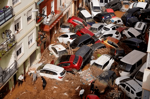
Valencia. Spain. 2024
Sea level along Spain’s coasts has risen and accelerated since the late 20th century. Since 1993, the sea level has risen by 9 cm, and models project continued rise through mid-century and beyond (tens of centimeters by 2050; up to 0.3–1.0 m by 2100, depending on emissions and ice-sheet behavior). That rise is already changing coastal geography (beach loss and erosion), pushing local and national planning to invest in protection, restoration, and, in some places, retreat, and it is starting to push up insurance costs and change cover availability.
Spain is a country deeply rooted in a “sun and beach” tourism. Due to this strong economic reliance on its coasts, the government has a National coastal protection and adaptation strategy led by MITECO (Ministry for the Ecological Transition and the Demographic Challenge), responsible for policies on ecological transition, energy, environment, water, climate change, and the demographic challenge. MITECO is already rolling out a mix of hard protection, beach nourishment, and ecosystem-based measures, along with planning reforms. These measures are multi-decadal and will cost from millions (local projects) to many billions (national/regional protection portfolios), depending on ambition and budget.
Is YOUR town at risk of going underwater in Spain? NASA reveals interactive map of predicted sea level rises due to climate change – with multiple expat havens on alert
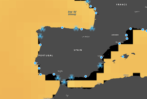
The highest predicted sea-level rise by NASA in Spain will be seen in Santa Cruz de Tenerife, the capital of Tenerife in the Canary Islands, with levels expected to rise by 81cm in the next 80 years. Popular tourist cities Cadiz and Barcelona are the second-highest at-risk areas, both predicted to see a 75cm sea-level rise. The changes can already be seen in Barcelona, where 6 to 10 meters of sand are lost each year due to global warming.
Other cities in Spain at risk of being submerged by increasing sea levels in 2100 are:
- Valencia (+71cm sea level rise)
- Málaga (+61cm)
- Almería (+60cm)
- Alicante (+58cm)
- Palma de Mallorca (+66cm)
- Santander (+72cm)
- Gijón (+66cm)
- A Coruña (+73cm)
- Vigo (+71cm).
Globally and in Europe, the rate of sea-level rise has increased since the late 20th century (global mean sea level rise accelerated from roughly a few mm/yr to 3–4 mm/yr in recent decades). That global acceleration shows up regionally as variations (some Spanish tide gauges record lower or higher trends depending on local subsidence, winds, and ocean circulation).
Long tide-gauge and satellite records show that the Spanish Atlantic and Mediterranean shores have experienced sea-level rise, more frequent storm-surge extremes, and coastal erosion. Some Mediterranean sectors (e.g., around Barcelona/Maresme) have seen substantial beach retreat and periodic rapid sand losses following storms; authorities report measurable local coastline retreat and recurring sand replenishment needs.
On the Ground Examples
- Recurrent beach nourishment projects (putting sand back on beaches) and localized seawalls/breakwaters around many urban beaches.
- Increased frequency and severity of flooding during storm surges and high tides in low-lying coastal parts of cities and resorts.
What are the sea level rise projections (2025–2050 and beyond)
- By 2050 (moderate confidence / depending on emissions): IPCC AR6 and regional analyses find a likely additional rise of order 0.15–0.3 m (15–30 cm) above late-20th/early-21st baseline in global mean sea level under typical scenarios; local values can differ a little but are broadly similar for much of the Spanish coast. Even this amount drastically increases the frequency of extreme coastal flood events (e.g., 1-in-100-year floods can become much more common).
- To 2100 and beyond: Projections diverge by emissions pathway and ice-sheet response; likely 2100 ranges are roughly 0.28–1.0 m, depending on the scenario (lower end for strong mitigation, higher if emissions remain high and there’s accelerated Antarctic ice-sheet loss). The Mediterranean has seasonal and regional quirks (storminess, changes in wave height) that compound the impact. Small mean rises (decimeters) translate into large increases in frequency and extent of coastal flooding and coastal erosion when combined with storms and high tides.
How sea-level rise is affecting: insurance, planning, and coastal geography
Home insurance/premiums
- Insurers in Spain and globally are factoring in growing climate risk; reinsurance costs rise after major events and get passed to consumers. Insurers (including major Spanish groups) report increasing losses from coastal storms and floods, which raise premiums, restrict coverage in the highest-risk zones, or lead to risk-based pricing (higher premiums for properties with repeated flooding or known erosion exposure). Some markets are beginning to require stronger risk assessments for underwriting coastal properties.
Community and city planning
- Municipalities and the national government are updating coastal planning rules, including setback distances, restrictions on rebuilding in high-erosion zones, risk maps, and coastal adaptation strategies. Spain’s national coastal protection strategy and regional plans are pushing municipalities to account for future SLR when permitting infrastructure and housing. Investment is shifting from one-off emergency fixes to longer-term adaptation planning.
Coastal geography (beaches, wetlands, and infrastructure)
- Beach loss and erosion are visible along many Spanish coasts (Mediterranean beaches, especially, have lost significant sand in recent years); hard structures (seawalls, groynes) alter sediment transport and can worsen erosion downcoast. Wetlands and low-lying land face permanent inundation or more frequent saltwater intrusion, with knock-on effects on habitats, groundwater, and farmland.
What Spain (and regions) are doing now — main approaches
Spain is using a mix of approaches at the national, regional, and local levels:
- Protection (hard engineering): seawalls, revetments, breakwaters—used to defend high-value urban infrastructure and ports. (Short-term effective but expensive and can cause downstream erosion.)
- Beach nourishment and maintenance: frequent in tourist beaches (adding sand). This is recurring and costly. Local examples (e.g., the Barcelona metropolitan coast) require tens of millions for stabilization projects.
- Ecosystem-based measures: dune restoration, wetland/lagoon restoration, and “living shorelines” to absorb wave energy and provide habitat—encouraged in national guidance.
- Planning, regulation, and managed retreat: updated coastal planning guidance, setback zones, prohibitions or restrictions on new development in very exposed places, relocation incentives in some cases. Spain’s national coastal protection and adaptation frameworks guide regions and municipalities.
- Monitoring, mapping, and early warning: tide gauges, remote sensing, risk mapping, and decision tools (IPCC/Copernicus tools are used for local planning).
How long will these efforts take?
Adaptation is multi-decadal to permanent. Many measures (seawalls, nourishments, ecosystem restoration) must be maintained indefinitely or until a managed retreat occurs. National planning reforms and large coastal projects are planned over decades (now → 2050 → 2100). IPCC and European work highlight that meaningful adaptation planning and implementation typically require actions phased over years to multiple decades to be effective.
How much will it cost?
Costs depend on what is chosen (protect everywhere vs selective protection vs retreat):
- Local projects: millions to tens of millions of euros (e.g., estimates of €60 million quoted to stabilize 42 km of metropolitan Barcelona coast in local press). These pay for beach nourishment and coastal protection works.
- National/European aggregates: analyses of economically efficient protection across Europe suggest billions to low hundreds of billions of euros this century, depending on the level of protection and scenarios. One European analysis shows adaptation costs for coastal protection in the tens of billions by mid-century and much larger by 2100 under higher warming scenarios. Copernicus/EEA work gives ranges (for Europe) of €13–39 billion by 2050 (for certain scenarios and adaptation packages) and much higher totals by 2100 for more damaging pathways. These are order-of-magnitude estimates—Spain’s share depends on what it protects and how it does so.
Protecting every kilometer of coast to the highest standard is astronomically expensive; most analyses recommend prioritizing investments (protect critical assets, allow nature-based solutions where possible, and plan retreat where costs are unreasonable).
My (practical) view on limits for future coastal development
A policy recommendation grounded in risk management must include clear, implementable limits that many coastal jurisdictions could apply:
- Mandatory future-sea-level setback zones: require new development to be set back from the present shoreline by a distance that accounts for projected erosion over the life of the development (e.g., planning horizon 30–50 years).
- No net increase in exposure in highest-risk zones: disallowing new residential or critical infrastructure development in areas that models show will be regularly flooded by 2050 (or where the cost of protection exceeds realistic budgets).
- Risk-based insurance and disclosure: require property sellers to disclose flood and erosion risk and require insurers to reflect risk in pricing—paired with social safety nets for affordability.
- Rolling easements / managed retreat triggers: allow the shoreline to migrate inland (no permanent armouring where it would harm adjacent coasts); set criteria that trigger relocation rather than repeated rebuilding.
- Prioritize nature-based solutions first where effective: dunes, marshes, and oyster/sea-grass restoration that reduce wave energy and provide ecosystem benefits.
These measures would reduce long-term public liability and avoid lock-in of assets that will be unaffordable to protect later. They are consistent with Spain’s national strategy direction and international best practices.
Quick actionable takeaways for a policymaker, homeowner, or planner:
- Homeowners: check up-to-date flood/erosion risk maps, expect premiums to reflect risk, and plan for higher costs or loss of coverage in exposed properties.
- Local planners: use NASA and IPCC/Copernicus projections for planning horizons (2050 and 2100), adopt setback rules, and prioritize nature-based measures where feasible.
- National/regional: prioritize funding to protect critical infrastructure, incorporate managed retreat where protection is infeasible, and develop financial instruments to share costs fairly (public-private partnerships, insurance pools, resilience funds).
This Post was submitted by Climate Scorecard Spain Country Manager, Juanjo Santos.