

Sea level rise (SLR) is a critical aspect of global climate change, particularly affecting coastal regions, including low-lying areas of southern Africa.
Sea level rise in South Africa, a direct consequence of climate change, is an accelerating trend that poses significant threats to coastal property, infrastructure, and communities. The primary effects are increased coastal erosion and more frequent and severe flooding during storm events. The trend shows that, along the South African coast, the sea level has risen at a rate of approximately three millimeters per year in recent decades, consistent with global averages. This represents a sharp increase in sea levels from historical rates, with a significant portion of the total rise since 1880 occurring in the last 25 years.
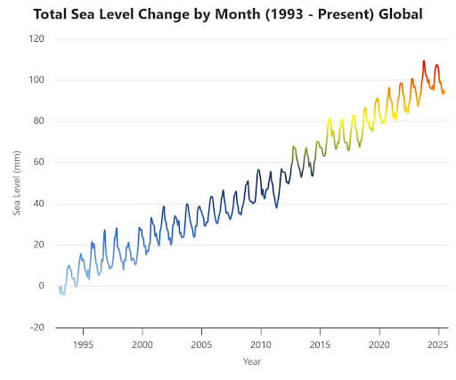
The global mean sea level has increased since the end of the 19th century. Sea level rise is accelerating and will continue to rise over the 21st century and beyond. On top of the global mean signal, there are large regional variations in the magnitude of sea level rise. Projections for South Africa indicate a likely rise of approximately 0.5m under a low-emissions scenario, or as much as 0.85m (with a potential range up to 1.4m or more) under a high-emissions scenario.
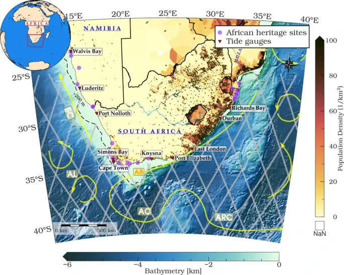
Sea level rise (SLR) is a critical aspect of global climate change, particularly affecting coastal regions, including low-lying areas of southern Africa (Fig. 2 below). Projections indicate that by 2035, approximately 143 million people will reside within 100 km of the coast in this region1–3, making it highly susceptible to the adverse impacts of rising sea levels.
Sea-level rise (SLR) events will affect people in different ways. Those living on property that is less than five meters above sea level are at high risk of permanent inundation and frequent storm damage. This risk is a primary consideration in new coastal planning guidelines.
On the other hand, insurance companies are becoming more aware of the escalating hazard, but property valuers have historically not factored SLR risk into market values. This is changing. As the likelihood of SLR risks increases, insurance becomes more costly until it is no longer viable.
Cities like Cape Town and Durban are conducting extensive risk assessments to identify vulnerable areas and plan for long-term mitigation. Planning involves identifying high-risk zones and preventing new developments in these areas to save lives and future economic loss. This often involves difficult social and economic decisions regarding existing communities. The National Environment Management: Integrated Coastal Management (ICM) Act provides a legal framework for this by using the 1-in-50-year flood line and elevation above sea level to define no-development zones. This approach aims to prevent the creation of new vulnerabilities and save future economic and social losses.
This Post was submitted by Climate Scorecard South Africa Country Manager, Rugare Zhou.
Engagement Resources
- https://climateknowledgeportal.worldbank.org/country/south-africa/sea-level-historical
- https://www.ipcc.ch/sr15/
- Kemgang Ghomsi, F.E., Erkoç, M.H., Raj, R.P. et al. Sea level trends along the South African coast from 1993 to 2022 using XTRACK altimetry, tide gauges, and GNSS measurements. Sci Rep 15, 4946 (2025). https://doi.org/10.1038/s41598-025-89258-9
- 9. Nhantumbo, B., Nilsen, J. Ø., Backeberg, B. & Reason, C. The relationship between coastal sea level variability in South Africa and the Agulhas Current. J. Mar. Syst. 211, 103422. https://doi.org/10.1016/j.jmarsys.2020.103422 (2020)
- The National Environment Management: Integrated Coastal Management (ICM) Act 24 of 2008